
EHSShala
Environmental Monitoring Guide for Indian Factories | EHSShala
EHSSaral is an Environmental Compliance Intelligence Platform for Industries. Consent Intelligence • Alerts & Tasks • Incident Reporting • Form IV & V • Audit-Ready Records
See how EHSSaral works
8 Oct 2026
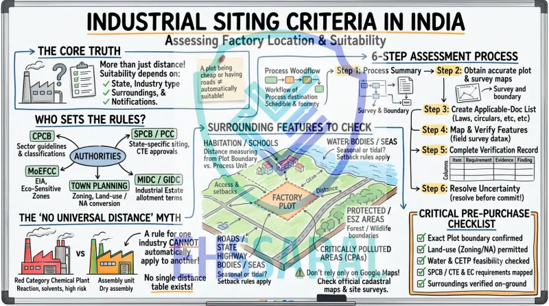
Quick Answer: Industrial siting criteria help determine whether a particular industrial activity can be established at a particular location. In India, the assessment can involve State Pollution Control Board/Pollution Control Committee (SPCB/PCC) requirements, Central Pollution Control Board (CPCB) sector guidelines, land-use permissions, notified-area restrictions and other applicable approvals. There is no single distance table suitable for every factory. Start with the proposed manufacturing process and exact plot boundary, identify the applicable requirements, and verify each relevant condition against reliable records.
A plot is available at a reasonable price. It has road access, electricity nearby and enough space for production. Other factories are operating in the surrounding area.
Does that make it suitable for your proposed industry?
It is a promising starting point, but the location assessment is still incomplete.
The manufacturing process, permitted land use, nearby water bodies, surrounding habitation, applicable restrictions and availability of suitable infrastructure all need consideration. Two industries looking at the same plot may reach different conclusions.
For a factory owner, the useful question is: “What evidence do I need before treating this land as suitable for my project?”
This guide explains how to assess industrial siting criteria in India, which documents to collect, how to interpret distance requirements and how to organise the findings into a practical site-verification record.
Scope note: This article provides general guidance for preliminary assessment. It is not a site approval or legal opinion. Apply the current requirements relevant to the state, industrial activity and specific location, including amendments and applicable directions or court orders.
Industrial siting criteria are requirements governing where an industrial activity may be located and, where specified, its separation from surrounding features.
These features can include habitation, roads, water bodies, schools, hospitals, protected areas and other sensitive locations.
However, a complete site assessment extends beyond minimum distances.
It also asks:
A useful assessment distinguishes three different findings.
| Type of finding | What it means | Appropriate response |
|---|---|---|
| Location restriction | An applicable provision prohibits or limits the proposed activity at the location | Establish the exact applicability before treating the site as viable |
| Additional approval requirement | The location or project characteristics trigger another permission or appraisal | Identify the authority, requirements and approval sequence |
| Practical infrastructure constraint | Water supply, treatment capacity, access or another essential facility is insufficient | Establish whether a technically and legally acceptable arrangement is available |
These findings should remain separate. An additional approval requirement does not automatically mean that a location is prohibited. Equally, available infrastructure does not remove a location restriction.
For example, a nearby Common Effluent Treatment Plant (CETP) may help with wastewater management. Its presence does not establish that the proposed activity is permitted on the plot or that the facility can accept the particular wastewater.
Industrial siting involves several authorities because environmental suitability, land use and development permissions address different questions.
| Authority or institution | What to examine |
|---|---|
| CPCB | Relevant sector guidelines, directions and industrial classification documents |
| SPCB or PCC | State or Union Territory siting requirements, consent procedures, circulars and applicable directions |
| Ministry of Environment, Forest and Climate Change (MoEFCC) and relevant environmental authorities | Applicable environmental clearance provisions and notified environmental restrictions |
| Town-planning and development authorities | Permitted land use, development plans, zoning and building requirements |
| Industrial development corporations or estate authorities | Plot allotment conditions, permitted activities and common infrastructure arrangements |
| Groundwater, coastal, forest, wildlife and other competent authorities | Requirements arising from the proposed resource use or location |
The task is to identify which requirements apply to the proposed project and how they interact.
Online searches for CPCB or SPCB siting criteria often show distances such as 500 metres, 5 kilometres or 25 kilometres. These figures may come from documents covering different industries, locations and purposes.
For example, the Wildlife Institute of India’s published guidelines for siting of industry describe a 5 km conservation zone and a 5–25 km regulatory zone around sensitive or protected areas. The latter includes consideration of development based on specified studies. Summarising this as a blanket 25 km prohibition changes the meaning of that guidance.
Similarly, MPCB publishes separate siting criteria for hot mix plants. A sector-specific distance should not automatically be applied to another manufacturing activity.
Before using any distance, identify:
The age of a document alone does not establish whether it remains applicable. Equally, a recently updated webpage may reproduce an older provision.
Record the relevant requirement and its source before comparing it with the site measurement.
Industry category is an important input, but the assessment also needs the actual process, capacity, fuels, water requirement, emissions and waste streams.
“Engineering unit” or “pharmaceutical unit” may be too broad a description for this purpose. Dry assembly, metal finishing and chemical synthesis involve different processes and environmental considerations.
Confirm the applicable category using the relevant entry and its qualifications. EHSSaral’s guide to industry categorisation in India explains this classification framework.
Avoid assigning a category based only on the product name. Supporting operations such as painting, washing, chemical treatment or fuel combustion can be relevant to the assessment.
These approvals address different parts of the project.
Environmental clearance under the Environmental Impact Assessment (EIA) framework is generally handled by MoEFCC or the relevant State Environment Impact Assessment Authority (SEIAA), subject to the applicable category and provisions.
SPCB/PCC consent is a separate process. Land-use and development permissions are addressed through the competent planning or development authority.
For the site assessment, prepare a project-specific approval list rather than assuming that one permission settles every question.
EHSSaral’s Consent to Establish guide explains the wider consent application workflow.
Begin with the plot and proposed activity together. A location cannot be assessed meaningfully when either is poorly defined.
Obtain the plot’s survey or cadastral identification and check the applicable planning records.
Establish:
Land ownership, revenue classification, planning designation and building approval are different records. Review the relevant combination rather than relying on one document.
Where non-agricultural conversion or a similar permission is relevant, verify the state-specific route and applicable exceptions.
As a Maharashtra example, MPCB published a circular dated 29 July 2025 concerning verification of building/development permission when granting Consent to Establish (CTE) to units proposed outside industrial areas. Applicants should examine that circular together with subsequent clarifications applicable to their case. See MPCB’s building/development permission circular.
For an owner, the useful outcome is a clear answer to two questions: what use is currently supported by the documents, and what further permission is needed for the proposed activity?
Identify nearby settlements and places where people may be particularly affected by dust, noise, odour, emissions or industrial hazards.
Depending on the applicable requirement, relevant features may include:
Read how the document defines the receptor. A village centre marker on an online map may not represent the boundary or reference point specified in the requirement.
Also record relevant features observed during the site visit even when they are missing from online maps.
A small group of buildings, a recently opened school or an occupied neighbouring property may deserve examination even if the online map has no label for it.
Document nearby water features and drainage routes.
A channel that is dry during a summer visit may carry substantial monsoon flow. Its appearance on one date does not establish its classification or regulatory relevance.
Check:
Separate a legally prescribed setback from a practical drainage concern. Both may affect site selection, but they need different evidence and responses.
Ask how stormwater currently leaves the plot and whether the proposed construction would obstruct that route. This is easier to address during site selection than after the building footprint has been finalised.
Review applicable road setbacks and access permissions, where relevant.
For preliminary feasibility, also assess whether tankers, raw-material vehicles, waste transport vehicles and emergency vehicles can access the proposed facility safely.
A road may appear wide enough on a map while having narrow approaches, restricted turning space or unsuitable connections.
Check the complete approach route, not only the road immediately outside the gate.
Record these constraints before finalising the layout, loading areas and storage locations.
Distance checks are one part of site assessment. Wind patterns, ground levels and surrounding development also help determine how the proposed operation may affect neighbouring areas.
During preliminary screening, consider:
Use suitable meteorological information where the assessment requires it. Wind observed during one site visit is not a reliable description of year-round conditions.
These findings can inform the positioning of material storage, treatment facilities and emission sources. They can also help identify where detailed impact assessment or monitoring design is needed.
Where ambient monitoring is required, establish locations using the applicable requirements and site conditions rather than assuming a fixed number of stations or equal spacing.
Where a site may be affected by an Eco-Sensitive Zone (ESZ) or another environmental notification, retrieve the relevant notification and amendments.
MoEFCC publishes individual ESZ notifications, including maps and subsequent changes. Use the applicable notified boundary and activity provisions rather than a general assumption about distance from a national park or sanctuary. See MoEFCC’s ESZ notifications.
The review should distinguish:
A nearby protected-area name is a signal to investigate. It does not, by itself, complete the assessment.
For a potentially coastal site, check the applicable Coastal Regulation Zone (CRZ) framework and approved Coastal Zone Management Plan.
Do not use distance from the visible sea edge as the sole assessment.
The applicable framework also needs verification. The Government has explained that updated plans under the 2019 framework require approval, and the 2011 provisions continue to apply until the relevant updated plans are approved. See the official explanation of CRZ implementation.
Use the relevant approved map and applicable provisions to identify the site’s position and the implications for the proposed activity.
If a proposed site falls within an identified polluted industrial area, check the defined area boundary and current project-related directions.
Historical restrictions should not be treated as automatically current. CPCB records show that moratoria in certain critically polluted areas have been imposed and subsequently lifted subject to conditions.
The relevant current position needs a location-specific review.
Record the applicable direction, its date and how it affects the proposed new unit or expansion.
For a water-dependent process, establish the proposed source and required quantity early.
Separate process water, cooling or utility requirements, cleaning water and domestic use. Identify any seasonal or peak demand that could affect the supply arrangement.
If groundwater is proposed, check the competent authority, current assessment-unit category and applicable eligibility and permission conditions. Do not group “Critical” and “Over-exploited” into one automatic approval or rejection outcome.
The official groundwater framework distinguishes these assessment categories and links them to groundwater-resource assessments. See the CGWA consolidated guidelines.
An existing borewell is evidence of infrastructure on the site. Further review is needed to establish the proposed abstraction’s permission status, suitability and reliable yield.
For the wider workflow, refer to EHSSaral’s groundwater NOC guide for factories.
A plot may accommodate the production building but leave insufficient space for the environmental and safety arrangements needed to operate it.
Before finalising the site, prepare a preliminary layout that accounts for:
| Space requirement | What to check |
|---|---|
| Greenbelt and planting | Applicable area, width, location and planting conditions |
| Effluent Treatment Plant (ETP), Sewage Treatment Plant (STP) and associated tanks | Treatment capacity, maintenance access and sludge handling |
| Waste storage | Segregated storage, containment and collection-vehicle access |
| Stormwater drainage | Drainage routes and separation from potentially contaminated areas |
| Internal access | Vehicle movement, emergency access and equipment maintenance |
| Future expansion | Space for additional utilities and pollution-control capacity alongside production |
Establish greenbelt requirements from the applicable provisions and project conditions. A figure found online, such as a 500-metre-wide belt or a percentage of plot area, should not be assumed to apply to every factory.
Also distinguish a greenbelt within the site from a separation distance between the industry and a nearby feature. They serve different purposes and are not automatically interchangeable.
This layout exercise helps identify whether the available land is practically sufficient before building dimensions and production capacity are finalised.
Some checks deserve attention only when the project or location triggers them.
| Project or location feature | Additional matter to investigate |
|---|---|
| Hazardous chemical storage or processing | Applicable chemical-safety requirements, separation provisions and emergency-planning implications |
| Tall buildings, stacks or structures near an airport | Applicable height restrictions and clearance requirements |
| Centrally protected monument nearby | Prohibited and regulated-area provisions |
| Proposed factory building | Applicable factory site, building and plan-approval requirements |
| Forest land or uncertain forest status | Relevant land records and forest-related permissions |
| Project potentially covered by the EIA Notification | Environmental clearance applicability and location-related appraisal requirements |
Use this table to identify work that needs specialist review. It is not a universal approval checklist.
The National Monuments Authority explains that the minimum prohibited area extends 100 metres from the protected limit of the centrally protected monument or site.
The regulated area extends a further 200 metres from the limit of the prohibited area. These limits can be extended through the applicable process.
Therefore, the two distances do not share the same starting point. Check the notified protected limits and applicable provisions before interpreting a measurement. See the National Monuments Authority FAQs.
A location-related provision can change the appraisal route rather than create a blanket prohibition.
The Government’s explanation of the 2014 EIA amendment records a change from 10 km to 5 km for the relevant General Condition, subject to specified stipulations. This makes a universal “all factories need to be 10 km away” statement unreliable.
For an actual project, examine the current EIA Notification, amendments, applicable Schedule entry and General Condition. Establish both whether environmental clearance applies and what the location changes.
The historical amendment is an illustration of why context matters, not a substitute for checking the current project-specific position.
MPCB’s location-restrictions page lists several distinct areas and subjects, including Dahanu, Bhatsa, Matheran, coastal regulation and sector-specific criteria.
The practical lesson is to search for both the industrial activity and the location. A sector guideline alone may not identify every applicable area restriction. See MPCB’s restrictions for locating industries.
The general site-screening method remains useful across industries, but the details change with the activity. A stone crusher, poultry farm and concrete batching plant create different site-planning questions.
The following checks help owners prepare a meaningful assessment. They are not a substitute for the applicable distance schedule, consent requirements or location-specific restrictions.
For a stone crusher, assess the complete operation: unloading, crushing, screening, conveyors, stockpiles and vehicle movement. Measuring only from the crusher machine can leave important parts of the site unexamined.
Prepare a layout showing the plot boundary, equipment, storage areas, access roads and nearby features named in the applicable siting provisions.
Priority checks include:
For Maharashtra, review MPCB’s environmental guidelines for stone crusher units dated 10 January 2024, together with applicable siting provisions and subsequent amendments. Maharashtra Pollution Control Board
Owner’s practical question: Does the site accommodate the whole crushing and handling operation, including its controls?
If a quarry supplies the crusher, assess the quarry-related permissions separately. Proximity to a raw-material source does not establish the crusher site’s suitability.
For poultry farms, start with the type of operation, maximum number of birds housed at one time, shed arrangement and proposed expansion. Include manure, litter, wash-water and dead-bird management in the site assessment.
Priority checks include:
CPCB’s Environmental Guidelines for Poultry Farms, January 2022 provide a sector-specific reference. Check subsequent directions and the applicable state position, including consent applicability. mpcb.gov.in
Owner’s practical question: Where will manure, litter, cleaning water and dead birds be managed during normal operation?
An agricultural setting alone does not complete the environmental location assessment.
A Ready-Mix Concrete (RMC) plant needs assessment of aggregate storage, cement silos, batching, loading and transit-mixer movement. State whether the proposal is a commercial plant or a captive plant serving a dedicated project.
Priority checks include:
MPCB published revised RMC siting guidelines dated 17 October 2025. The document addresses Maharashtra-wide requirements and distinguishes commercial and captive plants. Review its applicability and subsequent changes before relying on older guidance. Maharashtra Pollution Control Board
Owner’s practical question: Can mixers enter, queue, load, wash and leave within a workable layout?
Calling a plant “temporary” or “captive” is not enough to establish which requirements apply.
For a brick kiln, identify the proposed technology, capacity, fuel and raw-material source before assessing the location. Include material preparation, drying, firing, storage and vehicle movement.
Priority checks include:
Review the brick-kiln environmental standards notified through G.S.R. 143(E), dated 22 February 2022, and the associated implementation material, alongside applicable state requirements and amendments. Maharashtra Pollution Control Board
Owner’s practical question: Have the kiln location and raw-material sourcing arrangement both been assessed?
An existing kiln nearby should prompt a check of applicable spacing requirements, rather than be treated as evidence that another kiln can be established.
For a hot mix plant, document the capacity, heating system, fuel, aggregate handling and bitumen-storage arrangements. Include tanker unloading and dispatch operations in the preliminary layout.
Priority checks include:
For Maharashtra, consult MPCB’s environmental standards and siting criteria for hot mix plants dated 10 January 2024, together with subsequent applicable provisions. www.mpcb.gov.in
Owner’s practical question: Does the plot accommodate heating, storage, loading and pollution-control arrangements as a complete operation?
An RMC plant and a hot mix plant involve different processes. Do not transfer a location criterion from one to the other merely because both serve construction projects.
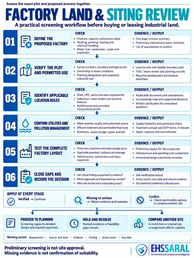
The following workflow summarises the main checks before buying or leasing factory land. Use it to identify the evidence needed, record unresolved questions and decide whether the site is suitable for further planning. The detailed steps below explain how to organise the assessment.
Describe the proposed operation clearly enough for someone else to assess it.
Include:
Avoid assessing a site for “assembly” when painting, washing or surface treatment is also planned.
Where information is preliminary, label the assumptions. This allows the assessment to be updated when the process design becomes clearer.
Collect the survey numbers, boundary plan, coordinates, ownership or lease records and relevant planning documents.
Use the actual plot polygon where possible. A single map pin can conceal how close one corner of a large plot lies to a receptor or restricted boundary.
Resolve discrepancies between the offered land, recorded parcel and proposed project area.
If several adjoining parcels are being purchased, establish which are included in the factory proposal and how access and infrastructure will be arranged.
Search for:
Retain the full documents, including annexures and maps. Record amendments and clarifications.
For each important provision, note why it applies to the proposed project. This is more useful than collecting a folder of circulars without an applicability assessment.
Prepare an initial surroundings map, then verify the features that matter to the applicable requirements.
If a mapped stream, settlement edge or boundary is uncertain, record the uncertainty and identify the evidence needed to resolve it.
Retain the mapping source, date, reference points and any supporting survey information. A later reviewer should be able to understand how the measurement was obtained.
For each important site question, record the requirement, evidence and unresolved action. A verbal assurance is useful background, but the decision should be supported by documents that relate to the actual plot and proposed activity.
Use the following table to organise the review.
| Check | Evidence to collect | What to verify | Who can help |
|---|---|---|---|
| Plot identity and boundary | Survey numbers, land records, boundary plan and survey information | The offered land, documented parcel and proposed project boundary match | Surveyor and property adviser |
| Ownership, lease and access | Relevant title or lease documents, access records and restrictions | The intended occupation and access arrangements are supported by the documents | Property lawyer and relevant land authority |
| Permitted industrial use | Planning designation, development permissions and allotment conditions | The proposed activity is compatible with the permitted use; further permissions are identified | Architect, planner or competent authority |
| Sector-specific siting criteria | Relevant circular, notification or direction, including amendments | The requirement applies to this process, location and proposal | Environmental consultant and SPCB/PCC where clarification is needed |
| Nearby habitation and sensitive features | Reliable maps, site observations and measurements | Features are correctly identified and distances use the prescribed reference points | Surveyor and environmental consultant |
| Water bodies and drainage | Relevant official records, site levels and drainage observations | Feature status, applicable restrictions and runoff paths are understood | Relevant authority, surveyor and civil/environmental engineer |
| Notified or restricted areas | Applicable notification, amendments and boundary maps | The plot’s position and implications for the proposed activity are established | Relevant competent authority and specialist adviser |
| Water supply | Demand estimate and source-specific supply or permission records | Quantity, quality and the proposed supply arrangement are feasible | Utility provider, groundwater authority where relevant and project engineer |
| Wastewater management | Preliminary water balance, treatment concept and receiving-facility terms where applicable | Treatment and the proposed final management route are suitable and permissible | Environmental engineer and receiving-facility operator |
| Layout feasibility | Preliminary layout showing production, utilities, treatment, storage and access | Essential facilities fit within the usable plot area | Architect and project/environmental engineers |
| Existing industrial premises | Available approvals, layouts, operational history and inspection records | The proposed use is assessed independently of the previous operation | Environmental consultant, engineer and legal adviser |
For every unresolved item, add an action owner and target date.
Use clear status descriptions:
These are internal review statuses. They do not constitute approval by an authority.
Where a location question could change project feasibility, seek clarification with a complete information package.
Include the process summary, plot identification, relevant provision, map and the precise question.
“Can we establish an industry here?” is difficult to answer. A documented question about a defined process and parcel is more useful.
Separate issues that need additional documents from those that need engineering work or an authority’s interpretation. Assign each to someone able to resolve it.
A distance is meaningful only when its starting point, endpoint and method are clear.
| Measurement question | What to establish |
|---|---|
| Where does measurement start? | Plot boundary, unit boundary, process area or another specified point |
| Where does it end? | Receptor boundary, protected limit, road reference line or other defined feature |
| What method applies? | The method stated or accepted under the applicable requirement |
| Which location is relevant? | The nearest relevant point rather than a convenient map marker |
| How reliable is the evidence? | Map scale, survey accuracy, feature identification and date |
Do not assume that road travel distance is the relevant separation distance.
Similarly, do not assume that moving a machine within the plot resolves a requirement expressed from the plot boundary.
Illustrative example: The plot centre is 720 metres from a feature, while the nearest plot boundary is 460 metres away. If the applicable requirement measures from the plot boundary, the centre-point measurement cannot establish compliance.
These are hypothetical measurements, not prescribed legal thresholds.
When the wording is unclear, record the possible interpretations and seek clarification. A conservative screening assumption should be labelled as an assumption.
Where a measurement is close to an applicable limit, its accuracy becomes especially important. Identify whether better boundary information or a suitable survey is needed before drawing a conclusion.
Google Maps and satellite imagery are useful for initial screening, site orientation and identifying features for investigation.
They can help a team understand surroundings before visiting the site. However, imagery does not necessarily establish legal boundaries, land-use permission or the regulatory classification of a water feature.
| Source | Useful purpose |
|---|---|
| CPCB and relevant SPCB/PCC websites | Guidelines, directions, circulars and consent-related requirements |
| PARIVESH and MoEFCC | Environmental approval information and relevant notifications |
| Bhuvan | Geospatial screening and available thematic information |
| State planning and development portals | Planning designations and development records |
| State revenue and cadastral systems | Parcel identification and land records |
| Relevant coastal or other competent authority | Applicable approved maps and location-specific information |
Bhuvan’s thematic information includes layers such as land use/land cover, water bodies and flood-related information. Check the layer’s date, scale and purpose before using it for a plot-level conclusion.
A land-cover layer showing built-up land does not, by itself, establish permission for the proposed industrial use. Use the source that answers the particular question being assessed.
A useful mapping record identifies the source, date, plotted boundary and measurement endpoints. Keep screenshots as supporting evidence alongside the underlying records.
For a Gujarat project, begin with the Gujarat Pollution Control Board’s official website and obtain the applicable siting circular, amendments and any relevant sector-specific provisions.
Search results can display several versions of a distance table. Before using one, record the document number, issue date, scope and whether a later document modifies it.
Prepare the following information for the review:
| Information | Why it matters |
|---|---|
| Manufacturing process and applicable category | Helps establish which provisions address the proposed activity |
| Industrial wastewater generation | Allows the assessment to consider any process-dependent distinctions in the applicable document |
| Survey numbers and plot boundary | Connects the assessment to the actual parcel |
| Industrial-estate status and planning designation | Helps identify which estate, planning and location provisions need examination |
| Nearby habitation, water features and sensitive locations | Provides the features to verify against the applicable definitions and measurement rules |
| New unit, expansion or relocation | Helps establish the proposal’s treatment under the relevant provisions |
Do not rely solely on a third-party map or summary to interpret an exception. Read its scope and conditions in the applicable official document.
Where applicability remains unclear, submit the process summary, plot details, map and precise question to the relevant GPCB office for clarification. Retain that response with the site-verification record.
A plot in a Maharashtra Industrial Development Corporation (MIDC) or Gujarat Industrial Development Corporation (GIDC) estate can simplify parts of project planning. The proposed activity still needs to fit the relevant plot conditions, estate conditions and regulatory requirements.
Before relying on an estate’s infrastructure or an existing factory’s permissions, ask for the supporting documents.
| What the owner may hear | Follow-up question | Evidence or confirmation to seek |
|---|---|---|
| “This is an industrial plot.” | Is this particular manufacturing process permitted under the plot and estate conditions? | Allotment or lease conditions and applicable permitted-use records |
| “A CETP is available.” | Can it accept our wastewater quantity and characteristics, and what pretreatment is required? | Written connection or acceptance terms, inlet conditions and relevant capacity information |
| “Water is available.” | How much can be supplied, at what quality, and how reliable is the supply? | Plot-specific allocation or supply terms and an assessment against demand |
| “Power is already connected.” | Does the available supply meet our machinery and utility load? | Existing sanctioned load and confirmation of any required enhancement |
| “A factory was operating here.” | What did it manufacture, and how does that differ from our proposed process? | Previous approvals, layouts and a documented comparison with the proposed operation |
| “The shed has all approvals.” | Which approvals cover the building, and which cover the industrial activity? | Building/development records and relevant environmental permissions |
| “There is a drain outside.” | Is it a stormwater drain, sewer or effluent network, and is our proposed connection permitted? | Network identification and written connection/discharge conditions |
| “There is enough space to expand.” | Will expansion also require more treatment, storage, water, power or access space? | Preliminary expanded layout and utility assessment |
A nearby treatment facility does not establish that it can receive the proposed wastewater. Similarly, a visible drain does not establish an acceptable discharge route.
For an existing industrial property, also ask about previous chemical handling, underground tanks, waste storage and any reported spills or contamination. The history helps determine whether further inspection is appropriate.
Use the estate’s advantages as verified project inputs, rather than assumptions.
This example is hypothetical. The distances are assumed observations, not statutory limits or approval conclusions.
A promoter is evaluating a plot outside a designated industrial estate in Maharashtra.
Preliminary mapping suggests:
Two possible projects are being considered:
Option A: Bulk-drug manufacturing involving chemical synthesis, solvent handling and process wastewater.
Option B: Dry assembly of purchased components, without painting, plating, chemical surface treatment or process washing.
| Issue | Option A: Chemical synthesis | Option B: Dry assembly |
|---|---|---|
| Process definition | Reaction stages, chemicals, solvents and recovery systems need assessment | Confirm the operation is limited to the described assembly activities |
| Classification | Verify the applicable entry and project characteristics | Verify the relevant entry; do not assume a category from “assembly” alone |
| Wastewater | Establish treatment and authorised management arrangements | Confirm whether any process wastewater exists; assess domestic sewage separately |
| Water source | Quantify demand and establish supply or abstraction eligibility | Quantify process, domestic and utility water needs and establish a lawful source |
| Nearby channel | Verify its status, applicable restrictions and drainage implications | The channel still needs verification despite the simpler process |
| Additional appraisal | Examine environmental clearance and chemical-related applicability | Assess the actual project against applicable triggers |
| Land use | Planning compatibility remains unresolved | Planning compatibility remains unresolved |
The available distances do not establish that either option meets the applicable criteria.
However, the comparison is useful: it shows why the chemical process requires a different scope of technical and approval review.
| Check | Evidence currently available | Preliminary finding | Next action |
|---|---|---|---|
| Plot identity | Survey reference and seller’s sketch | Boundary not independently established | Obtain reliable boundary information |
| Industrial land use | Verbal assurance | Evidence pending | Review planning records and required permissions |
| Seasonal channel | Online imagery | Feature status unresolved | Check records and inspect drainage |
| Groundwater | Borewell visible on site | Availability and permission status unresolved | Review the proposed use and applicable requirements |
| Effluent route for Option A | No acceptance or disposal arrangement | Material feasibility issue | Establish a suitable treatment and authorised management route |
| Sector-specific distances | No applicable document recorded | Assessment incomplete | Identify the relevant requirements before comparison |
The immediate output is a focused action list. It prevents assumptions from being mistaken for completed checks.
For the promoter, the next decision is whether the identified uncertainties can be resolved through documents, engineering work and relevant clarification within the project’s practical constraints.
| Common mistake | Better approach |
|---|---|
| Copying another state’s distance table | Verify jurisdiction, sector and applicability |
| Treating nearby factories as proof | Assess the proposed process and plot independently |
| Measuring from the map pin | Establish the required boundary and reference points |
| Ignoring a dry channel | Verify its recorded status and seasonal function |
| Treating land ownership as industrial-use permission | Review the relevant planning and development records |
| Assuming industrial category settles location suitability | Check sector and area requirements separately |
| Relying on a common treatment facility’s existence | Confirm eligibility, capacity and acceptance conditions |
| Treating an old circular as the complete position | Review amendments and subsequent clarifications |
| Recording “compliant” when evidence is missing | Record the unresolved issue and responsible person |
| Planning expansion only around production space | Assess additional utilities, treatment, storage and access needs |
| Assuming a previous occupant’s permissions cover the new operation | Compare the proposed project with the relevant existing records and identify required changes |
A prospective factory owner does not need to memorise every environmental provision. The practical objective is to define the intended operation, collect the right evidence and resolve questions that could change the land decision.
Use this checklist while comparing sites, before treating a plot as suitable for the project.
Give the same process description to the seller, architect, environmental consultant and project engineer. Otherwise, each person may assess a different version of the factory.
Include:
Describe activities precisely. “Engineering factory” does not reveal whether the project includes only assembly or also degreasing, painting, pickling and plating.
Where a quantity is not yet known, label it as an estimate and assign someone to refine it.
| Owner’s question | What a useful answer should contain |
|---|---|
| What exactly am I buying or leasing? | Identified parcel, established boundary, area, access and reviewed ownership or lease documents |
| Can I carry out my proposed activity here? | Planning and permitted-use review based on the actual manufacturing process |
| Which siting requirements apply? | Relevant documents, their scope and the required measurement basis |
| Have nearby features been checked? | Mapped and verified habitation, water features, roads and relevant restricted areas |
| Can I obtain enough suitable water? | Demand estimate matched to a feasible and authorised source arrangement |
| Where will wastewater go? | Treatment concept and a suitable, permissible reuse, discharge or off-site management arrangement |
| Can the land accommodate the complete factory? | Layout including production, treatment, greenbelt where applicable, storage, drainage and access |
| Are electricity and fuel arrangements workable? | Demand assessment, supply feasibility and space for associated equipment |
| Which permissions affect the project programme? | Project-specific approval list, dependencies, responsibilities and expected preparation work |
| What could still change this site decision? | A short list of unresolved restrictions, missing evidence and infrastructure constraints |
Treat this as a review checklist, not a scoring system. Several satisfactory items do not cancel one unresolved issue that could prevent the intended activity.
The following examples cover familiar manufacturing situations. They identify questions to investigate, rather than assign a pollution category or approval outcome.
| Proposed industry | Process detail that changes the assessment | Priority land and infrastructure checks |
|---|---|---|
| Dry assembly and packaging | Whether work includes washing, printing, coating, adhesives or solvent use | Permitted activity, process scope, material storage, utilities and waste handling |
| Engineering and fabrication | Machining and welding versus painting, pickling, plating or heat treatment | Noise and fume sources, chemical handling, wastewater where generated and treatment/storage space |
| Food processing, bakery or dairy | Dry processing versus washing, liquid processing and frequent equipment cleaning | Water demand, peak cleaning wastewater, treatment capacity, organic waste and odour management |
| Garments and textiles | Stitching versus dyeing, bleaching, printing or washing | Water and effluent arrangements, chemical storage, utilities and suitable treatment access |
| Plastics moulding or extrusion | Purchased clean feedstock versus scrap sorting, washing or recycling | Feedstock storage, process emissions, wastewater where generated and activity-specific requirements |
| Chemical blending or manufacturing | Simple mixing versus chemical reactions, heating and solvent recovery | Chemical inventory, emissions, process wastewater, waste management and emergency access |
| Pharmaceutical operations | Formulation versus bulk-drug or intermediate synthesis | Detailed process review, applicable approvals, solvents, wastewater characteristics and treatment arrangements |
A factory can fall into more than one row. For example, an engineering business that operates a plating line needs the surface-treatment process assessed even if plating is a small part of total production.
Consider these examples during planning.
Assembly with an added painting line: A shed initially assessed for dry assembly may later need space and arrangements for paint storage, ventilation, emissions control and waste handling. Disclose the painting process at the site-selection stage.
Food processing with frequent cleaning: Water demand and wastewater generation can rise sharply during cleaning periods. Ask the engineer to examine these peaks rather than using only a daily average.
Plastic processing with scrap washing: A unit using clean purchased granules and a unit washing incoming scrap have different water and wastewater questions. “Plastic factory” is not a sufficient process description.
Textile stitching with future dyeing: An empty portion of the plot does not establish that wet processing can be added. Review the future process, water source, treatment route and applicable requirements separately.
These examples show why site screening should include utilities and supporting operations, not just the main production machine.
Once location and approval questions are understood, compare the costs of making each viable site operational.
| Cost item | What to include in the comparison |
|---|---|
| Land preparation | Levelling, drainage and necessary civil works |
| Utility connections | Water, electricity, fuel and associated installation requirements |
| Wastewater management | Treatment, connection, conveyance and recurring charges |
| Environmental facilities | Applicable controls, waste storage and monitoring access |
| Logistics | Raw-material, finished-product and waste transport |
| Usable space | Land remaining after essential facilities, access and applicable setbacks |
| Project programme | Unresolved permissions and infrastructure dependencies |
A lower land price can be outweighed by expensive utility connections or an unsuitable wastewater arrangement. Obtain preliminary engineering estimates before treating two plots as financially comparable.
For example, one plot may have a higher purchase price but an established suitable water connection and an acceptable wastewater arrangement. Another may require significant additional infrastructure. Compare the complete project implications using evidence and estimates for each site.
Summarise the assessment in one of the following ways:
| Internal decision | What it means |
|---|---|
| Suitable for further project development | No material conflict has been identified in the completed screening; required approvals and detailed design remain to be addressed |
| Potentially suitable, subject to named actions | Specific documents, confirmations or infrastructure arrangements remain outstanding |
| Alternative site recommended | An identified restriction or impractical arrangement makes the plot unsuitable for the intended project |
For a conditional decision, record the exact action, responsible person and evidence needed to close it. Avoid a vague conclusion such as “approval should be possible.”
Coordinate this review with the Consent to Establish process. After permissions are obtained, carry the relevant consent conditions into the layout, construction plan and operating arrangements.
A useful land assessment should leave the owner able to explain why the plot suits the proposed factory, what evidence supports that conclusion and what remains to be resolved.
Do not assume that a CPCB document alone provides the complete location requirements. Check its scope alongside the applicable SPCB/PCC provisions, state requirements and location-specific notifications.
There is no single distance table suitable for every industrial activity and location. Identify the relevant sector and jurisdictional provision before selecting a distance for assessment. Also check how the provision defines habitation and its measurement points.
A 25 km figure should not be treated as a universal setback for every factory. It appears in published guidance with particular contexts and qualifications. Identify the source, its applicability and the current requirements for the proposed activity and location before using it.
Do not assume these widths apply to every factory. Check the applicable sector requirements, environmental clearance, consent and development conditions. Confirm whether a stated figure concerns an internal greenbelt, an external buffer or separation from a sensitive feature.
Start with a precise process description and the relevant SPCB/PCC website. Search for the industry, siting or location criteria, circulars and amendments. Then check applicable CPCB documents and area-specific restrictions.
It can support preliminary screening. A final assessment needs the applicable requirement, reliable boundary information and evidence suited to the feature being checked. A map pin or screenshot alone does not establish land-use permission or site approval.
The proposed activity, plot conditions, estate conditions and infrastructure arrangements still need review. Keep written evidence of the relevant permissions and service arrangements, including wastewater acceptance where applicable.
They address different matters. Review industrial-use and development requirements through the competent planning authority and the relevant environmental consent requirements through the pollution-control authority.
Compare their issuing authority, legal basis, scope, dates and amendment history. Check whether one expressly modifies the other. Seek documented clarification where the apparent conflict remains material to the site decision.
Include a location and approval review in the proposed change assessment. New processes, capacities, chemical inventories, water demand or additional land can change the matters that need examination.

Founder, EHSSaral
Founder - EHSSaral | Partner - Perfect Pollucon | ISO 14001 Lead Auditor | GHG Protocol Scope 2 | Chemist | Data Scientist | Second-generation environmental professional simplifying EHS compliance for Indian industries through practical, automated, tech-enabled, data driven compliance workflows.
Environmental Monitoring Guide for Indian Factories | EHSShala
Factory Act & Compliance Thresholds: What Applies to Your Headcount? | EHSSaral
TSDF Hazardous Waste Process: Manifest, Disposal & Records
Environmental Compliance Calendar Software – Simplify MPCB Renewals & Due Dates | EHSSaral
 Guide for Indian Factories EHSShala by EHSSaral.webp)
Ambient Air Quality Monitoring (AAQM) Guide for Indian Factories | EHSShala
Form V Data Collection: Monthly System for Factories
Used Oil & Waste Oil Management in India - Factory & EHS Guide | EHSShala
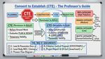
Consent to Establish (CTE) Explained: Process, Documents, Rules & Common Mistakes | EHSShala
 based on Pollution Index (PI) scores for 2025 environmental compliance V1.webp)
Industry Categorization in India: Red, Orange, Green, White & Blue | EHSShala
 ehssaral.webp)
4-Stream Waste Segregation for Factories (SWM 2026) | EHSSaral